A Walk Up Kirkton Glen
With the weather forecast looking like we were going to get a decent weekend at last, Lorna fancied going for a walk in the hills. Sounded good to me and it'd give me a chance to break in my new, light hiking shoes and try out my new camera. Mind you, I'd worn the shoes all day Saturday just to get a feel of them and they were pretty comfortable.
So, after poring through the walk books and maps, we decided to head for Balquhidder and walk up to the top of Kirkton Glen. Rob Roy Macgregor, one of our more famous or infamous Scots, lies buried in the kirkyard there and it's a place I've never visited before so we'd get to take in a bit of our heritage as well.
Kirkton Glen runs north(ish) from Balquhidder, probably somewhere between two and a half and three miles up to the top so bank on at least a five mile hike. The walk starts from the back of the church and there's plenty of parking there but it's a busy place with visitors to the graveyard so don't be surprised to see quite a few cars there. The O.S. map of the glen makes it look like it's all pretty much forested but most of it has been cleared of trees. That's good news if you don't like hiking uphill through a warm and humid forest and the warmth brought out some late butterflies so I was happy enough chasing these around and trying out my new camera.
 Green-veined White butterfly
It's a pretty straightforward walk, if a bit strenuous as you climb just over 1,500 feet doing it. You follow the path north on the right side of the burn for about an hour until you get to a fork in the road. The left fork goes down towards the forest and, if you go that way, it crosses the burn and curves back round and back down to Baquhidder along the edge of the forest. Continue on instead and you'll soon come to a bench at a curve on the path and just across from it is a small footpath heading off north into the hills and signed for Glen Dochart and you can clearly see the rising summit of Leum an Eireannaich ahead. The main path continues curving round and turns south towards Balquhidder again so you want to take the Glen Dochart path. We had lunch, sitting on the bench so it's a nice place to stop and rest for a while.
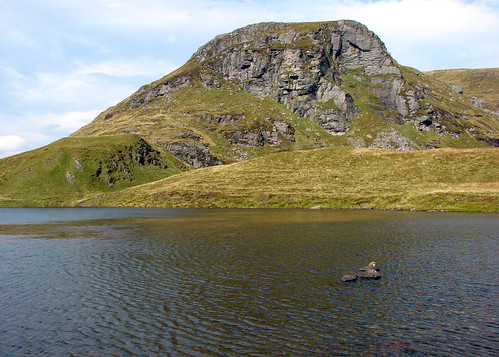
All you have to do then is follow the Glen Dochart track up overt he hill until you reach Lochan an Eireannaich, which is another nice place to sit and relax against the backdrop of the cliffs of Leum an Eireannaich. On the way up you'll pass a huge boulder, noted on the map as Rob Roy's Putting Stone. It's obviously split away from the cliffs and has slid down a fair way before coming to rest. The lochan looks nice enough for a swim but it's probably freezing. Might be good for fishing as there was a good splash from a reasonably sized trout at one point. We had a wander round the loch and it was well populated with tapdoles and we also saw a few tiny froglets near the water's edge.
If you walk on past the lochan and through the beallach onto the hill beyond there are some good views to be had of Ben More and Stob Binnean to the west and the Mamlorn Hills to the north. You could keep on going, following the path down into Glen Dochart, if you had the means of getting back to Balquhidder but the normal return route is back the way you came until you hit the place where the main path curves and you can take any of the three routes down.
As for the new shoes...they did the job as well as I'd expected. Great for light hikes on decent paths or tracks but not quite enough ankle protection for serious climbing. The Sony DSC H2 camera also performed very well, once I'd figured out where some of the functions were.


No comments:
Post a Comment