Bracorina To Stoul
It’s Monday and it looks like the rain is going to hold off, at least in the West, so we threw together a pack lunch and headed along the North side of Loch Morar to the end of the road at Bracorina. This the starting point of two popular walks and there’s room for six or seven cars to park here.
If you’re feeling energetic, there’s the long walk along the loch side to Tarbet on Loch Nevis but it’s a 15 mile round trip unless you organise the ferry to pick you up and take you back to Mallaig. We’ve wandered along about half of this walk before and we really didn’t feel up to a trek of that length this time.
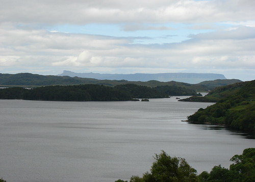 Loch Morar and Eigg
The shorter walk is over the hill to the old deserted hamlet of Stoul on the shore of Loch Nevis. The path to Stoul heads off North just after crossing the bridge at the end of the car park. It’s well signed so you can’t miss it, just turn left after going over the bridge. This is quite a strenuous walk so make sure you’ve got decent boots on and clothing to cope with any weather.
The sign at Bracorina says 2.5 miles to Stoul but this very generous and it’s probably closer to three by the time you spend losing and re-finding the path at the Stoul end so that makes it about a six mile round trip. The guides for the walk say that the maximum height gained is 235 metres (765’) but you’ll do that a few times over the day so you’ll have climbed over 1,500’ by the time you’re done.
The path is well defined at the start and climbs up until you get to Lochan Innis Eanruig. All the way up there are some good views back over Loch Morar and out to the islands of Eigg and Rùm. The path then skirts round the edge of that little lochan and heads over the peat hags and down to Lochan Stole, where you have to cross the loch by means of a quaint stepping stone bridge. Once over the stones, the path runs up and along the east shore of the lochan until it climbs up to Bealach nan Sac, which is about as high as you get on the walk. It then drops very steeply down to Stoul on the shore of Loch Nevis.
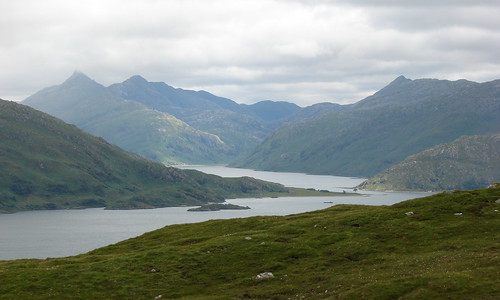 Sgurr na Ciche, Garbh Chioch Mhor and Sgurr na h-Aide
The views from the top of the bealach are splendid. You can see over Loch Nevis to Inverie in Knoydart, one of the most inaccessible parts of Scotland. You can also look up Loch Nevis to where it narrows at Kylesmorar and Kylesknoydart and, if the clouds are being kind, all of that is presented against the amazing backdrop of the pinnacled summits of Sgurr na Ciche, Garbh Chioch Mhor and Sgurr na h-Aide.
We lost the path once we started down to Stoul as it degenerated into a lot of sheep tracks through heavy bracken. This is where that 235 metres height comes in as that’s about how far the drop is to Stoul so it is very steep and care must be taken if you are going to go down. You can see the ruined houses and shingle beach from the top and I suspect a lot of walkers don’t go much further than that, thinking about the hard climb back up, and that probably accounts for the lack of a decent path as well.
Undaunted, we worked our way down towards the largest ruined house, which had a large Scots Pine beside it. It was a good place to head for as there was a gate in the fence, allowing us through to the houses and beach. The hamlet is split into Easter and Wester Stoul, on either side of a small shingle beach, but all of the buildings have been abandoned. Those with roofs are now the territory of the local sheep so I doubt if anyone would be keen to spend a night in any of them.
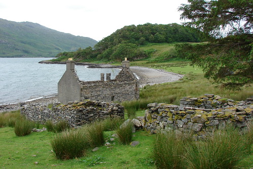 Wester Stoul
We parked our bums under the big Pine tree and got a bit of shelter from the biting wind from that and a bit of old ruined wall. We had a rest and a bit of lunch before heading back across the beach to Easter Stoul to look for the path back up. Needless to say, what looked like the right path also disappeared into the bracken and we ended up just striking straight up to the top of the bealach the hard way. That’s over 760 feet (235 metres) from sea-level in a very short distance and our legs were aching by the time we got up there.
Once at the top we spotted the original path over the moor so it easy to cross over to that and trudge wearily back to Bracorina.
If you’re feeling energetic, there’s the long walk along the loch side to Tarbet on Loch Nevis but it’s a 15 mile round trip unless you organise the ferry to pick you up and take you back to Mallaig. We’ve wandered along about half of this walk before and we really didn’t feel up to a trek of that length this time.
Loch Morar and EiggThe shorter walk is over the hill to the old deserted hamlet of Stoul on the shore of Loch Nevis. The path to Stoul heads off North just after crossing the bridge at the end of the car park. It’s well signed so you can’t miss it, just turn left after going over the bridge. This is quite a strenuous walk so make sure you’ve got decent boots on and clothing to cope with any weather.
The sign at Bracorina says 2.5 miles to Stoul but this very generous and it’s probably closer to three by the time you spend losing and re-finding the path at the Stoul end so that makes it about a six mile round trip. The guides for the walk say that the maximum height gained is 235 metres (765’) but you’ll do that a few times over the day so you’ll have climbed over 1,500’ by the time you’re done.
The path is well defined at the start and climbs up until you get to Lochan Innis Eanruig. All the way up there are some good views back over Loch Morar and out to the islands of Eigg and Rùm. The path then skirts round the edge of that little lochan and heads over the peat hags and down to Lochan Stole, where you have to cross the loch by means of a quaint stepping stone bridge. Once over the stones, the path runs up and along the east shore of the lochan until it climbs up to Bealach nan Sac, which is about as high as you get on the walk. It then drops very steeply down to Stoul on the shore of Loch Nevis.
Sgurr na Ciche, Garbh Chioch Mhor and Sgurr na h-AideThe views from the top of the bealach are splendid. You can see over Loch Nevis to Inverie in Knoydart, one of the most inaccessible parts of Scotland. You can also look up Loch Nevis to where it narrows at Kylesmorar and Kylesknoydart and, if the clouds are being kind, all of that is presented against the amazing backdrop of the pinnacled summits of Sgurr na Ciche, Garbh Chioch Mhor and Sgurr na h-Aide.
We lost the path once we started down to Stoul as it degenerated into a lot of sheep tracks through heavy bracken. This is where that 235 metres height comes in as that’s about how far the drop is to Stoul so it is very steep and care must be taken if you are going to go down. You can see the ruined houses and shingle beach from the top and I suspect a lot of walkers don’t go much further than that, thinking about the hard climb back up, and that probably accounts for the lack of a decent path as well.
Undaunted, we worked our way down towards the largest ruined house, which had a large Scots Pine beside it. It was a good place to head for as there was a gate in the fence, allowing us through to the houses and beach. The hamlet is split into Easter and Wester Stoul, on either side of a small shingle beach, but all of the buildings have been abandoned. Those with roofs are now the territory of the local sheep so I doubt if anyone would be keen to spend a night in any of them.
Wester StoulWe parked our bums under the big Pine tree and got a bit of shelter from the biting wind from that and a bit of old ruined wall. We had a rest and a bit of lunch before heading back across the beach to Easter Stoul to look for the path back up. Needless to say, what looked like the right path also disappeared into the bracken and we ended up just striking straight up to the top of the bealach the hard way. That’s over 760 feet (235 metres) from sea-level in a very short distance and our legs were aching by the time we got up there.
Once at the top we spotted the original path over the moor so it easy to cross over to that and trudge wearily back to Bracorina.


No comments:
Post a Comment